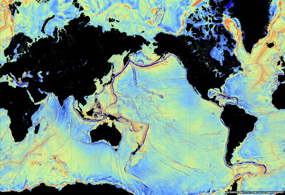
We know more about the outer space than we know about our oceanic floor. Exploring the deep waters has always been a difficult task, but now we finally have access to a truly detailed map of the ocean floor. The data reveals plenty of previously unknown mountains.
The result is surprising, as there was no scientific project aimed at mapping the areas. No underwater expeditions were needed to come up with new data. Instead, two satellites orbiting the Earth for another project provided data used to draw the most detailed representation of undersea geography.
The European Space Agency launched the Cryo-Sat2 satellite to observe how the ice cap changes. The French space agency and NASA placed another satellite on the orbit with the aim to measure sea levels. By pointing the instruments at the water surface, the satellites measured the changes in the surface water topography.
Gravity helps the underwater structures have a representation on the oceanic surface. If water lies over a seamount, its level will be higher. Similarly, a trench would make the ocean level to drop just enough to be visible with the help of proper instruments and detailed measurements.
Thousands of undersea mountain peaks have been discovered. More precisely, around 15,000 of them, a stunning number. We might have known more about the topography of Earth’s neighboring planet, Mars, than about the ocean floor until now. Water proves to be much more difficult to penetrate than the vast void between the two planets.
The results have been published in Science journal on Friday. The lead study author, David Sandwell, is a marine geophysicist at the Scripps Institution of Oceanography in La Jolla, California. “I think these data are pretty important in terms of the details that are going to come out,” Sandwell told LiveScience.
Using the previous mapping methods we only had access to undersea mountains taller than 1.2 miles, Sandwell said. But the team has not managed yet to process all the data retrieved from the satellites, so other important details will come out at a later time.
The discovery will have deep implications over a large number of fields. The new data will help fishing management and conservation agencies take more informed measure. The detailed mapping will help meteorologists understand how the ocean currents move and, consequently, they can come up with better weather forecasts. A deeper knowledge of the undersea topography will lead to advances in seismology as well.